How to Use the Calculator
The King County Right Size Parking Calculator allows you to view estimated parking/unit ratios for multi-family developments throughout urban areas of King County, WA (Seattle area). The calculator is based on a powerful model developed from current local data of actual parking use. While it is intended to help support and guide parking supply and management decisions, it should not be viewed as a definitive answer. Rather, it should be seen as a resource to inform discussions, weigh the factors impacting parking demand, and help consider the proper provision of parking.
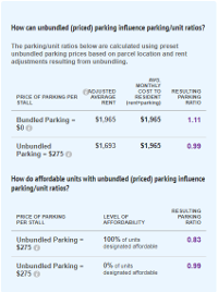
For any location selected, users are encouraged to develop scenarios and view the influence on parking/unit ratios by adjusting the model inputs. To help demonstrate the influence of priced parking, bundled and unbundled parking preset options are automatically generated for the parcel(s) that are selected in order to guide the user’s decisions. Bundled assumes parking costs are “free” to the tenant, but are recovered through higher rental rates. Unbundled assumes parking cost is separated from rent, granting tenants a choice in parking use and resulting in lower total tenant costs.
Find your Area
Enter a location above or use the zoom and pan tools on the map. To select parcels, you must zoom in close enough to see individual parcel boundaries. Once you’re close enough, the selection tools in the upper right of the map will become active.
Select your Parcel(s)

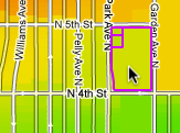
Click the “Select” button and click on the parcel(s) you’d like to inspect. You will see a parking/unit estimate appear in the box above. To unselect a parcel, click the parcel a second time and then click “Remove parcel.” Or to clear all choosen parcels click the “Clear” button to the far right of the “Select” button.
To select a larger area:
Neighborhood or City: Use the “Select Area” drop down
Custom Area: Click the “Draw” button and create a custom area to select parcels. As you are selecting parcels, the parking/unit estimates will assume one building (as defined in the Building and Parking Specifications tab) on each parcel. If you wish to build one building on multiple parcels, click the “Merge” button.
Creating Scenarios
Once you have selected the parcel(s) of interest, you have the option to click through the “Building and Parking Specifications” and “Location Characteristics” tabs to adjust the default inputs.
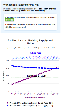
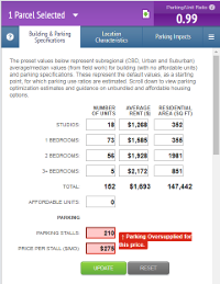
Be sure to view the “Optimized Parking Supply and Market Price Optimized Parking Supply and Market Price” on the “Building and Parking Specifications” tab to help develop your scenario, and optimize the supply of parking.
Also, view the preset unbundled parking and affordable housing options on the “Building and Parking Specifications” tab to help develop your scenario.
View Results
Parking/Unit Ratio: The box above will show the estimated parking spaces per residential unit for the selected building(s), called the parking/unit ratio. When multiple parcels are selected, it will show an average. To view additional information about the selection, click the down arrow in the purple box.
Parking Impacts: This tab provides average parking construction costs and estimated vehicle miles traveled (VMT) and greenhouse gas (GHG) emissions based on the amount of parking.
Selection Info: Click the up arrow in the bottom right for trip generation reduction estimates and Census data on average commute distance and journey to work mode split.
Note: Areas of the map without the Parking/Unit Ratio thematic color map are outside of the model’s geographic coverage.
A project in collaboration with King County and the Center for Neighborhood Technology. Contact Us.